


Nature, history and places to visit
Ria Formosa guide: nature and history, place by place
Everything you see on our tours, from Cacela Velha to Santa Luzia: 18 places with their story and photos, 44 birds, fish, shellfish and plants, and how the lagoon was formed. Tap a point on the map or choose a section.
The lagoon map
All the places on our tours. Tap a point to see what it is. The small circles show where you see flamingos, octopus, oysters and other animals.
Schematic map: real positions, approximate channels.
Places to visit
From east to west: what you see from the boat, the story, photos and sources. For each place, the tours that pass there.
-
Fábrica Beach, opposite Cacela VelhaPhoto: Titus Boat Tours Beach
Fábrica pier and beach
The small pier sits at the end of the road down from Cacela Velha, and this is where our beach boat leaves from. Across the channel lies the sand of Fábrica Beach, which you can only reach by boat. At low tide, sandbanks appear and shellfish gatherers dig for clams; at high tide, the water covers everything and turns emerald green.
The story
The name comes from the Cacela ceramics factory (Fábrica de Cerâmica de Cacela), founded in 1889 by the Companhia Algarviense. It worked from 1892 to 1930, making bricks, roof tiles and clay pipes. The factory is gone, but it gave its name to the place and to the beach.
Did you know? From the pier to the beach is just a few minutes by boat: we make this crossing every day, with tickets from €1.50.
Tours that pass here: Santa Luzia tour Tavira tour Cacela Velha tour Cabanas tour Grand tour Sunset tour Group boat tour Private boat with skipper
Sources: O sítio do Algarve que deve o nome a uma fábrica de cerâmica (Postal do Algarve)
-
Village
Cacela Velha
From the boat you see the white village on top of the cliff: the fortress wall, the church tower and the whitewashed houses, with the lagoon at their feet. The cliff that holds the village is a fossil cliff, about a million years old. In the late afternoon the light turns the houses golden: it is the most photographed view on this side of the Ria Formosa.
The story
In 713 Cacela came under Muslim rule, and the castle dates from the 9th and 10th centuries. The poet Ibn Darraj al-Qastalli, "the one from Cacela", one of the great poets of al-Andalus, was born here in 958. Paio Peres Correia conquered Cacela in 1240 and King Dinis granted it a charter on 17 July 1283. The 1755 earthquake ruined the church, the Misericórdia and the town hall, and brought down the bastions of the fortress: the cannons ended up on the beach. It was the seat of a municipality until 1775.
Did you know? Excavations in 2007 confirmed that the Islamic medina of Qast'alla Daraj stood here. The village has been listed as a Property of Public Interest since 1996.
Tours that pass here: Santa Luzia tour Tavira tour Cacela Velha tour Cabanas tour Grand tour Sunset tour Group boat tour Private boat with skipper
Sources: Cacela Velha (Wikipédia)
-
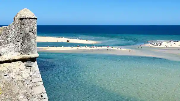
Sandbanks and clear water at the Cacela inletPhoto: Titus Boat Tours Nature
The inlet and the lagoons
The inlet is the lagoon's door to the sea. At the right tide, the water turns crystal clear and shallow pools form between banks of white sand. The waves break on the outside; on the inside the water is calm and warm. Gulls, herons and small waders often rest on the sand.
The story
The Ria Formosa is a coastal lagoon about 60 km long, from the Ancão Peninsula to Manta Rota, sheltered from the sea by five barrier islands and two peninsulas. Cacela is the easternmost. The inlets move with storms and currents: in the autumn of 2010 a storm broke through the Cacela peninsula and opened a new link to the sea.
Did you know? The Ria Formosa has been a Natural Park since 1987 (a Nature Reserve since 1978) and is a wetland of international importance for birds under the Ramsar Convention.
Tours that pass here: Cacela Velha tour Sunset tour Private boat with skipper
Sources: Parque Natural da Ria Formosa (Wikipédia), Ria Formosa, introdução (CIMA, Universidade do Algarve)
-
Fortress
Fort of São João da Barra
Just east of Cabanas, on a small hill above the lagoon, stands a star-shaped fortress with four bastions. Today it is a hotel, but the wall, the main gate and the stone plaques at the entrance are still there, facing the water.
The story
It was ordered in 1656, during the Portuguese Restoration War, by Nuno de Mendonça, military governor of the Algarve, to defend the coast of Tavira. It was enlarged between 1670 and 1672. The 1755 earthquake damaged it and it was restored in 1793, under Queen Maria I. In 1808 Captain Sebastião Martins Mestre took it back from the French with the help of the local people. It had a garrison until 1897 and was a customs guard post until 1905.
Did you know? Between 1857 and 1865 the first boys' school of the parish of Conceição worked here. In 1986 it was a setting for the film "À Flor do Mar" by João César Monteiro. It has been a Property of Public Interest since 1960.
Tours that pass here: Santa Luzia tour Tavira tour Cacela Velha tour Cabanas tour Grand tour Sunset tour Group boat tour Private boat with skipper
Sources: Fort São João da Barra (Wikipedia)
-
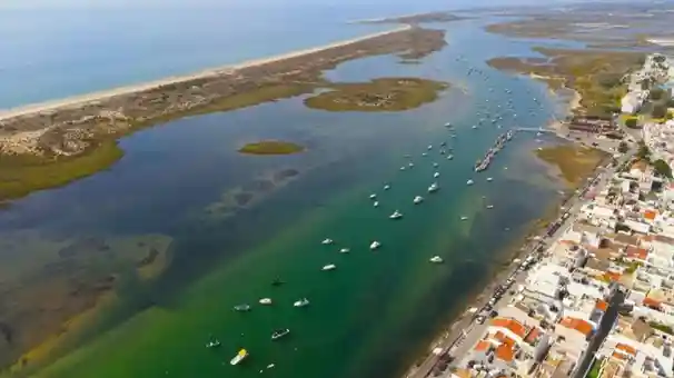
Cabanas de Tavira seen from the Ria FormosaPhoto: Titus Boat Tours Village
Cabanas de Tavira and its island
The Cabanas waterfront has fishing boats, café terraces and a long promenade by the water. Opposite lies Cabanas Island, with a long beach and dunes: about 7 km of sand in all. At low tide, the mud of the salt marsh fills with small fiddler crabs: the male has one huge claw, which he waves to attract a female.
The story
Around 1734 a tuna trap, the Armação dos Mares de Tavira, was set up here. The fishermen built huts ("cabanas") on the shore to keep their nets and sleep during the fishing season: hence the name. The first recorded birth is from 1757. Cabanas became a parish in 1997 and a town in 2001. Tourism arrived in 1973, with the first resort, Pedras da Rainha.
Did you know? The documentary "Almadraba Atuneira" (1961) by António Campos was filmed here. The beaches of Cabanas have had a Blue Flag since 1989.
Tours that pass here: Santa Luzia tour Tavira tour Cacela Velha tour Cabanas tour Grand tour Sunset tour Group boat tour Private boat with skipper
Sources: Cabanas de Tavira (Wikipedia)
-
Beach
Deserta Beach (Forte da Barra)
At the western tip of Cabanas Island, right next to the Tavira inlet, lies a quiet stretch of sand you can only reach by boat. On one side the sea comes in through the inlet; on the other, the lagoon water is calm and clear.
The story
The Tavira inlet, man-made and opened in 1950, separates Tavira Island from Cabanas Island. Deserta Beach is on the Cabanas side, facing the inlet.
Did you know? Deserta Beach is one of the stops of our water taxi: we take you there and pick you up, day and night.
Tours that pass here: Santa Luzia tour Tavira tour Cacela Velha tour Cabanas tour Grand tour Group boat tour Private boat with skipper
Sources: Ilha de Tavira (Wikipédia)
-
Fortress
Forte do Rato (Santo António)
Near the Tavira inlet, at the water's edge, stand the ruins of a small stone fort, with its gate and walls facing the channel. It was the first defence of the river mouth.
The story
It was built under King Sebastião (1568–1578) to protect the river mouth and the town from North African pirates. In 1573, when the king visited Tavira, it was still under construction. While it was being built, the river mouth moved east and the fort lost part of its purpose. In 1654 it was renamed Fort of Santo António. In 1792 it had nine men and two guns; in 1821, three men and no cannon. It was abandoned in 1840.
Did you know? It has been a Property of Public Interest since 1983. You can also see it from the Quatro Águas walking trail recommended by Tavira Town Council.
Tours that pass here: Santa Luzia tour Tavira tour Cacela Velha tour Cabanas tour Grand tour Sunset tour Group boat tour Private boat with skipper
Sources: Fort Santo António, Tavira (Wikipedia), Percurso «Os segredos e encantos da Ria Formosa», Câmara Municipal de Tavira
-
Beach
Tavira Island
A sand island about 11 km long, between the lagoon and the ocean. From the pier, a path crosses the dunes to the sea, with bars, restaurants and a campsite. From east to west it has four beaches: Ilha de Tavira, Terra Estreita, Barril and Homem Nu.
The story
The island used to be bigger. In 1926 the first Tavira inlet was opened, splitting the old "Great Tavira Island" in two; in 1941 a cyclone closed it and opened another. The present, man-made inlet was opened in 1950 and separates Tavira Island from Cabanas Island. Until 1943 there was a tuna fishing village on the island, at Medo das Cascas, destroyed by the sea.
Did you know? The beach gets a Blue Flag every year. When the last ferry has gone, our water taxi makes the crossing, day and night.
Tours that pass here: Santa Luzia tour Tavira tour Cacela Velha tour Cabanas tour Grand tour Sunset tour Group boat tour Private boat with skipper
Sources: Ilha de Tavira (Wikipédia), Percurso «Os segredos e encantos da Ria Formosa», Câmara Municipal de Tavira
-
Pier
Quatro Águas
This is the pier for the ferry to Tavira Island. Here the Gilão river meets the lagoon and the channels to Cabanas and Santa Luzia cross, close to the inlet that opens to the sea. All around are salt pans, salt marsh, fish restaurants and fishing boats.
The story
Along the Quatro Águas road there were salt pans and, from 1917, the tuna canneries. Next to the pier stands the old tuna fishermen's village, the Arraial Ferreira Neto.
Did you know? In spring, the salt pans between Quatro Águas and Luz de Tavira fill with flamingos.
Tours that pass here: Santa Luzia tour Tavira tour Cacela Velha tour Cabanas tour Grand tour Sunset tour Group boat tour Private boat with skipper
Sources: Percurso «Os segredos e encantos da Ria Formosa», Câmara Municipal de Tavira
-
Heritage
Arraial Ferreira Neto (former tuna fishing village)
A row of white houses along the river, with a chapel, a school and a pier with a hand crane. It was the village of the tuna fishermen. Today it is the Vila Galé Albacora hotel, which keeps a small museum about tuna fishing and the life of the families who lived here.
The story
It was designed in 1943 by the engineer Sena Lino, after the sea destroyed the previous village at Medo das Cascas, on Tavira Island. It had houses for 150 families, a school, a chapel, a medical post and five cisterns of 150,000 litres. Catches began to fall in 1961; in the 1970/71 season a single tuna was caught. It has been a Property of Public Interest since 2002.
Did you know? How a tuna trap worked: out at sea, a long net steered the tuna into a maze of fixed nets, held to the bottom by hundreds of anchors. At the end, the boats lifted the last net chamber and the tuna were hauled aboard by hand and with hooks: this was the "copejo". In spring they caught the tuna "de direito", heading for the Mediterranean; in summer, the tuna "de revés", on the way back.
Tours that pass here: Santa Luzia tour Tavira tour Cacela Velha tour Cabanas tour Grand tour Sunset tour Group boat tour Private boat with skipper
Sources: Arraial Ferreira Neto (Wikipédia), Percurso «Os segredos e encantos da Ria Formosa», Câmara Municipal de Tavira, A história da pesca do atum no Algarve (Barlavento)
-
Heritage
The canneries
On the bank of the Gilão, on the way to Quatro Águas, you can still see the tall chimney of the old Tavirense cannery. The Balsense stood on the other side of the river. This is where the tuna from the traps was cooked and canned in olive oil.
The story
The Tavirense started production in mid-June 1917, a month after the Balsense, which opened on 9 May 1917. That year the Algarve had 184 canneries and more than 14,500 workers. Tavira also had the cannery of José Matos Parreira and that of Manuel e João Baptista Calça, which canned tuna and sardines in olive oil. The Balsense closed in 1971. Of the Tavirense, only the ruins and the chimney remain.
Did you know? In 1898 King Carlos studied tuna fishing in the Algarve aboard the yacht Amélia: the traps recorded the time and number of tuna coming in, and the king compared them with the temperature, clarity and currents of the sea. The study is online at the National Library of Portugal.
Tours that pass here: Santa Luzia tour Tavira tour Cacela Velha tour Cabanas tour Grand tour Sunset tour Group boat tour Private boat with skipper
Sources: Tavirense, a antiga fábrica de conservas (Heritage Navigator), Tavira e a sua indústria (Folium, Universidade de Coimbra, 2024), D. Carlos, rei pioneiro no estudo da pesca do atum (Marinha)
-
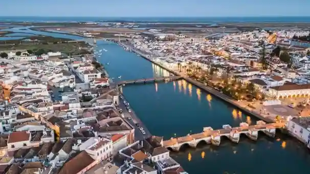
Tavira and the Gilão river at duskPhoto: Titus Boat Tours Town
Tavira and the Gilão river
We sail up the Gilão river to the town centre. From the water you see the old seven-arch bridge, the riverside gardens, the old Ribeira market, the castle and the church towers: there are more than thirty in town. Look out for the four-sided "scissor" roofs typical of Tavira.
The story
Tavira was born at the end of the Bronze Age and, in the 8th century BC, was one of the first Phoenician settlements in the west of the Iberian Peninsula. The Moors built the castle and the mosques. Paio Peres Correia conquered the town in 1242. The 1755 earthquake destroyed many of the buildings and the town was rebuilt. For centuries, fishing and tuna canning were Tavira's great wealth.
Did you know? The river changes its name at the bridge: upstream it is the Séqua, downstream the Gilão. It is called the "Roman bridge", but the one we see was rebuilt in 1667 on a much older crossing. Tavira represents Portugal in the Mediterranean Diet, UNESCO Intangible Heritage since 2013.
Tours that pass here: Santa Luzia tour Tavira tour Cacela Velha tour Cabanas tour Grand tour Sunset tour Group boat tour Private boat with skipper
Sources: Tavira (Wikipedia), A ponte que muda o nome a um rio (Postal do Algarve)
-
Nature
The Tavira salt pans
Large shallow pools separated by earth walls, in shades of white, green and pink. In summer you see the mounds of freshly harvested salt. Avocets, black-winged stilts, spoonbills, herons and, almost always, flamingos feed in the pools.
The story
The salt pans lie between the Gilão and Santa Luzia, about 500 metres from the Tavira inlet, and are filled only with sea water. Over the summer, sun and wind evaporate the water and the salt crystallises. It is harvested by hand. The Ria Formosa salt pans produce about half of Portugal's sea salt. Since 2013, Tavira Salt and Tavira Flor de Sal have had Protected Designation of Origin (PDO).
Did you know? The pink colour of the water comes from a microalga, Dunaliella salina, one of the few living things that can stand so much salt. It makes pigments (carotenoids) which, together with some bacteria, tint the water orange, purple and pink.
Tours that pass here: Santa Luzia tour Tavira tour Grand tour Sunset tour Group boat tour Private boat with skipper
Sources: O que ver nas Salinas de Tavira (idealista), Sal de Tavira e Flor de Sal de Tavira com DOP (Agroportal), Parque Natural da Ria Formosa: caracterização (ICNF), Percurso «Os segredos e encantos da Ria Formosa», Câmara Municipal de Tavira
-
Nature
The flamingos of the salt pans
Flocks of flamingos gather in the pools of the Tavira salt pans: long legs, long necks and curved bills. They feed upside down, stirring the mud with their feet and filtering the water through their bills. When they take off, the black feathers of their wings show. They do not like people coming close: from the boat you see them well without disturbing them.
The story
The greater flamingo (Phoenicopterus roseus) can be seen in the lagoon all year, but there are more in autumn, winter and spring. The Tavira salt pans are among the best places in the Algarve to see them, at any time of day, because the tide hardly affects the water in the pools. The flocks that visit Portugal usually nest in Spain, France, Italy or North Africa. In 2021, in a salt pan of the Castro Marim Salt Marsh Reserve, close by, a colony of about 3,000 flamingos built almost 800 nests and about 550 chicks hatched, according to the ICNF.
Did you know? Flamingos are not born pink: young birds are greyish with dark legs and only get their colour at about three years old. The pink comes from what they eat: algae and tiny shrimps from the salt pans, full of pigments. In a flock, they honk a lot like geese.
Tours that pass here: Santa Luzia tour Tavira tour Grand tour Sunset tour Group boat tour Private boat with skipper
Sources: Tavira Saltpans (Birdingplaces), Greater flamingos (Portugal Resident), Nasceram 550 flamingos no sapal de Castro Marim e Vila Real de Santo António (Postal do Algarve, 2021)
-
Beach
Terra Estreita
Across the channel, opposite Santa Luzia, lies Terra Estreita beach, on Tavira Island. It has a small pier, a beach restaurant and, a few minutes' walk over the dunes, a long beach facing the ocean.
The story
It is part of Tavira Island and of the Ria Formosa Natural Park. The name says it all: "narrow land", a thin strip of sand between the lagoon and the ocean.
Did you know? From Santa Luzia, our water taxi crosses to Terra Estreita in a few minutes.
Tours that pass here: Santa Luzia tour Tavira tour Grand tour Sunset tour Group boat tour Private boat with skipper
Sources: Ilha de Tavira (Wikipédia), Percurso «Os segredos e encantos da Ria Formosa», Câmara Municipal de Tavira
-
Nature
Oyster beds, seagrass and seahorses
At low tide the bottom of the lagoon is uncovered: rows of stakes, oyster bags and plots of sand where clams are farmed. The farmers work in high boots, to the rhythm of the tide. Under water, seagrass meadows shelter young fish, cuttlefish and seahorses.
The story
The lagoon has about 1,300 clam and oyster beds over 450 hectares, and it produces about half of the bivalves farmed in Portugal. In 2001 its seahorses were the highest density known in the world; in 2018 a survey showed a fall of about 90% in a decade, mainly due to illegal catching. In 2020 refuge areas were created, where boats may not go, and since 2021 seahorses bred in captivity have been released.
Did you know? There are two seahorse species in the lagoon: the long-snouted (Hippocampus guttulatus) and the short-snouted (Hippocampus hippocampus). In both, it is the male who gets "pregnant" and gives birth.
Tours that pass here: Santa Luzia tour Tavira tour Grand tour Sunset tour Group boat tour Private boat with skipper
Sources: Parque Natural da Ria Formosa: caracterização (ICNF), Os cavalos-marinhos da Ria Formosa vão ter refúgios (Postal do Algarve, 2019), Cavalos-marinhos aumentam na área protegida (Postal do Algarve, 2022), Cavalos-marinhos na Ria Formosa (Oceanário de Lisboa)
-
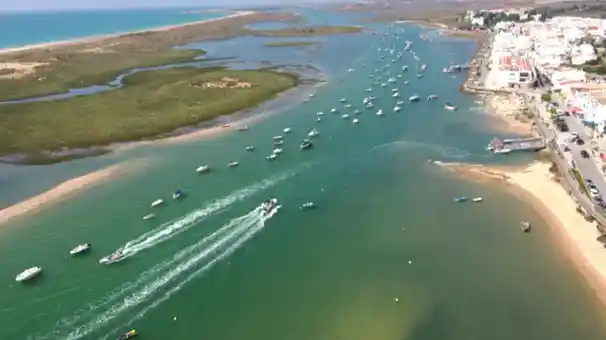
Santa Luzia seen from the Ria FormosaPhoto: Titus Boat Tours Village
Santa Luzia, the octopus capital
A long avenue along the lagoon, with fishing boats and octopus restaurants. On the quay are piles of "covos" and "alcatruzes", the octopus traps. The boats land octopus, squid, cuttlefish, fish and shellfish.
The story
The first records of the village, founded by fishermen, date from 1577. It is the smallest parish in the municipality of Tavira, about 850 hectares. Its patron saint is Saint Lucy, martyr of Sicily and protector of the eyes. The parish church, by the Algarve architect Manuel Gomes da Costa, was built between 1956 and 1958 on the site of a 16th-century chapel.
Did you know? Octopus is caught with "covos", baited traps, and with "alcatruzes", clay pots the octopus crawls into for shelter. That is why Santa Luzia is called "the octopus capital".
Tours that pass here: Santa Luzia tour Tavira tour Grand tour Sunset tour Group boat tour Private boat with skipper
Sources: Percurso «Os segredos e encantos da Ria Formosa», Câmara Municipal de Tavira, O polvo e as artes de pesca em Santa Luzia (Postal do Algarve)
-
Nearby
Barril Beach and the anchor cemetery
About 2 km from Santa Luzia, by land. It is not part of the boat tour, but it is worth a visit.
At Pedras d'El Rei, a bridge crosses the lagoon and a little train runs over the dunes to Barril Beach. On arrival, 248 iron anchors lined up on the sand: the anchor cemetery. The old houses of the tuna fishery are now restaurants, bars and shops.
The story
The Barril tuna trap (Armação dos Três Irmãos) was founded in 1867 by José Pires Padinha, from Tavira. It worked from April to September and the families lived in the fishing village. In 1881 it caught 46,825 tuna. It closed in 1966. The anchors held the trap nets to the sea bed.
Did you know? The Barril train runs about 1 km and was created to serve the tuna fishery. If you prefer, you can walk over the dunes.
Sources: A história da pesca do atum no Algarve (Barlavento), O cemitério à entrada desta praia algarvia (Postal do Algarve), Percurso «Os segredos e encantos da Ria Formosa», Câmara Municipal de Tavira
Lagoon life
Birds, fish, shellfish and plants you can see in the channels, the salt pans, the salt marsh and the dunes. If you have binoculars, bring them.
Birds 20
Greater flamingo Phoenicopterus roseus
Filters the water of the salt pans with its head upside down. Its pink comes from what it eats.
Eurasian spoonbill Platalea leucorodia
Its spoon-shaped bill sweeps the bottom from side to side.
Western swamphen Porphyrio porphyrio
Blue-violet, with a red bill and legs. It is the symbol of the Natural Park.
Little tern Sternula albifrons
The smallest of the terns. The largest colony in Portugal is in the Ria Formosa.
Little egret Egretta garzetta
All white, with a black bill and yellow feet. Seen all year round in the channels.
Grey heron Ardea cinerea
The largest heron in the lagoon: it waits motionless and catches fish in one quick strike.
Purple heron Ardea purpurea
Darker and slimmer than the grey heron, it likes reed beds.
White stork Ciconia ciconia
Nests on poles and chimneys and looks for food in the salt marsh.
Pied avocet Recurvirostra avosetta
Its thin, upturned bill sweeps the water from side to side.
Black-winged stilt Himantopus himantopus
Has some of the longest legs of any bird, for its body size.
Black-tailed godwit Limosa limosa
Arrives in winter from northern Europe to feed in the lagoon mud.
Whimbrel Numenius phaeopus
Its long, curved bill probes the mud for crabs and worms.
Common ringed plover Charadrius hiaticula
Small and quick: it runs on the sand and stops suddenly to pick up food.
Ruddy turnstone Arenaria interpres
Turns over stones, shells and seaweed with its bill, looking for food.
Common shelduck Tadorna tadorna
A large white duck with a dark green head and a red bill.
Great cormorant Phalacrocorax carbo
Dives after fish and then dries its open wings in the sun.
Kingfisher Alcedo atthis
A blue flash low over the water, diving after small fish.
Short-eared owl Asio flammeus
Hunts in low flight over the salt pans and salt marsh, often by day.
Hoopoe Upupa epops
The fan-shaped crest and its "hoo-hoo-hoo" call are unmistakable.
Iberian magpie Cyanopica cooki
Moves in noisy flocks in the pine woods and gardens near the lagoon.
Fish and seahorses 8
Long-snouted seahorse Hippocampus guttulatus
Holds on to the seagrass with its tail. The male is the one who gets pregnant.
Short-snouted seahorse Hippocampus hippocampus
The rarer of the two in the lagoon. About 150 bred in captivity were released in 2022.
Common cuttlefish Sepia officinalis
Changes colour in an instant to hide. In spring it comes close to the shore to lay its eggs.
Common octopus Octopus vulgaris
Three hearts, blue blood and eight arms full of suckers.
Gilthead seabream Sparus aurata
Has a golden band between its eyes. Young fish grow up in the lagoon.
European seabass Dicentrarchus labrax
Comes into the lagoon to hunt and to grow. One of the most sought-after fish.
White seabream Diplodus sargus
Recognisable by its dark stripes and the black spot near the tail.
Common sole Solea solea
A flatfish that lies on the bottom, half buried in the sand.
Shellfish and crabs 6
Grooved carpet shell clam Ruditapes decussatus
The star of the lagoon's shellfish beds: it lives buried in the sand and filters the water.
Oyster Crassostrea gigas
Farmed in bags and on trestles in the beds, it feeds by filtering the water.
Common cockle Cerastoderma edule
Lives a few centimetres deep in the sand and mud banks.
Razor clam Solen marginatus
A long shell like a razor. It digs itself in vertically, very fast.
Fiddler crab Afruca tangeri
The male has one huge claw, which he waves to attract a female.
Green crab Carcinus maenas
Lives in the channels and salt marsh and scuttles sideways at great speed.
Lagoon and dune plants 10
Seagrass Zostera noltei
Forms meadows on the lagoon bed: shelter for seahorses and young fish.
Cymodocea Cymodocea nodosa
One of the three seagrasses of the Ria Formosa, with long, narrow leaves.
Small cordgrass Spartina maritima
Covers the lowest parts of the salt marsh, flooded by the tide every day.
Perennial glasswort Sarcocornia
A succulent, salty plant of the higher parts of the salt marsh.
Limoniastrum Limoniastrum monopetalum
A salt-tolerant shrub with pink flowers, near the salt pans and the dunes.
Sea holly Eryngium maritimum
Silvery blue and very prickly, it grows on the island dunes.
Sea daffodil Pancratium maritimum
A white, fragrant flower that opens on the dunes at the end of summer.
Marram grass Ammophila arenaria
Its long roots hold the sand and help build the dunes.
Thrift Armeria pungens
Tufts of pink flowers on the dunes in spring.
Cistanche Cistanche phelypaea
Has no green leaves: it lives off other plants and grows spikes of yellow flowers.
The Ria Formosa
A coastal lagoon about 60 km long, from the Ancão Peninsula to Manta Rota, sheltered from the sea by five barrier islands and two peninsulas. It is the most important wetland in the Algarve for birds and has been a Natural Park since 1987.
- 60 kmof coast, from Ancão to Manta Rota
- 18,400 haprotected area
- 2 maverage depth
- 1.5 to 3.5 mdifference between high and low tide
- 200+bird species
- 100+fish species
- ½of the shellfish farmed in Portugal
- ½of Portugal's sea salt
How it formed
About 18,000 years ago, at the end of the last Ice Age, the sea was 120 metres lower than today. As the sea rose, the sandbanks were pushed towards the land, and the barrier islands reached their present position about 7,000 years ago. They have never stopped since: the inlets open, close and move east, and the islands grow on one side and lose sand on the other. Six inlets link the lagoon to the sea and, twice a day, the tide fills and empties it: about 90% of the lagoon is uncovered at low tide.
The habitats
- Salt marsh Muddy land flooded by the tide: a nursery for fish, cuttlefish and crabs.
- Salt pans Salt pools where flamingos and waders gather.
- Seagrass meadows Three species of seagrass: home of the seahorses.
- Sand and mud flats At low tide, a feast for the birds and the area of the shellfish beds.
- Dunes Almost fifty plant species, from the islands to the peninsulas.
- Channels The paths of the water, used by boats and fish.
Timeline
- 18,000 years agoThe sea is 120 metres below today's level.
- 7,000 years agoThe barrier islands reach their present position.
- 8th century BCTavira, one of the first Phoenician settlements in the west.
- 1950The man-made Tavira inlet is opened.
- 1978The Ria Formosa becomes a Nature Reserve.
- 1987It becomes a Natural Park.
- 2010A storm breaks through the Cacela peninsula and opens a new inlet.
- 2020Refuge areas are created for the seahorses.
On board, we look after the lagoon We watch the birds from a distance and slowly, without flushing them; we do not feed the animals; we leave no litter; and from the beach we take only photos.
Sources: Parque Natural da Ria Formosa: caracterização (ICNF), Ria Formosa, introdução (CIMA, Universidade do Algarve), Marés e circulação na Ria Formosa (LNEC), Parque Natural da Ria Formosa (Infopédia), Guia de boas práticas na Ria Formosa (CIMA, Universidade do Algarve), Os cavalos-marinhos da Ria Formosa vão ter refúgios (Postal do Algarve, 2019)
See the lagoon by boat
Our tours pass these places with a local skipper. Private, in a group or on the route you choose.
- Santa Luzia tourThe octopus village, from Tavira or Fábrica
- Tavira tourFrom Fábrica to the centre of Tavira, about 2h
- Cacela Velha tourThe inlet and the lagoons, 30 minutes
- Cabanas tourThe village and island of Cabanas, about 1h30
- Grand tourCacela, Cabanas and Santa Luzia, about 3h20
- Sunset tourLate afternoon, events and marriage proposals
- Group boat tourShared boat, about 3 hours, €30 per adult.
- Private boat with skipperThe boat just for you, on the route you choose.
Old photos and further reading
To see old photos and learn more about tuna fishing and the lagoon:
- "A Pesca do Atum no Algarve em 1898", King Carlos's study of tuna fishing, digitised by the National Library of Portugal
- Tuna fishing museum at the old Arraial Ferreira Neto (Quatro Águas)
- Free photos of the Ria Formosa on Wikimedia Commons
The photos are by Titus Boat Tours and from Wikimedia Commons (with the author and licence on each one). The facts come from the sources listed at each stop.